


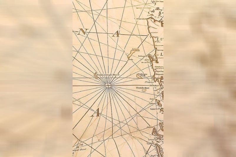
via Philippine Star, 21 November 2023: The Scarborough Shoal, originally named after the British East India Co. ship that struck the reef in 1748, first appeared on Philippine maps in the 1750s. This naming and mapping were initiated by English cartographers following the shipwreck. The shoal is depicted in the 1799 William Heather ‘Chart of the China Seas’ and the 1749 Murillo Velarde map under the name “Panacot,” also known as Bajo de Masinloc. These historical maps have recently garnered significant attention and value at auctions.
The contentious Scarborough Shoal may thus be seen in William Heather’s 1799 “Chart of the China Seas,” an example of which was sold to great enthusiasm at the recent León Gallery Bibliophiles and Explorers Auction. It also appears in the Murillo Velarde map in his 1749 book under the name “Panacot,” which also went to auction last weekend successfully. Both terms refer to Bajo de Masinloc.
The vellum-covered Murillo Velarde tome (1749), containing a book-sized version of the famous 1734 map engraved by Nicolas de la Cruz Bagay and an engraving of the Virgin of Antipolo by Laureano Atlas, skyrocketed to P3.4 million (inclusive of buyer’s premium) while the Heather China Seas map took in P780,000.
Source: Scarborough 1st appeared on maps of Philippine waters in 1750s | Philstar.com